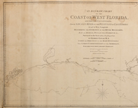
From 1764 to 1771, Scottish-born surveyor George Gauld (1731–1782) devoted his professional life to exploring and charting the northern coast of the Gulf of Mexico. Following the British acquisition of West Florida, in 1763, officials recognized the need for better intelligence concerning the “Isle of Orleans” and adjacent waterways—areas they thought might one day be navigated by British merchants or ships of war. Gauld was commissioned to map the coastal areas of newly Spanish Louisiana and British Florida and spent eight years surveying them firsthand. After hostilities erupted between Britain and Spain, Gauld was captured in Pensacola, in 1781, by Spanish forces under the command of Bernardo de Gálvez. He was eventually freed and allowed to return to England, where he died in 1782.
The quality of this survey and others by Gauld attracted the attention of geographer and publisher William Faden (1749–1836), who issued the surveyor’s work posthumously. Gauld’s monumental chart of the coasts of West Florida and Louisiana, which was issued in 1803, was engraved and printed on four large sheets. The entire chart, when assembled, measures over ten feet long. It is the crowning achievement of Gauld’s life’s work, encompassing over 850 nautical miles of the northern Gulf Coast and delineating bays, rivers, and lakes, whose depths and bottom characteristics are included in the rare admiralty chart. Commanders of the 1814 British expedition against New Orleans used the chart to plot their route to the city via Bayou Bienvenue.
Number:
12
Citation 1:
1803; printed map
Citation 2:
by George Gauld, surveyor; William Faden, publisher; Benjamin Baker, engraver
Accession #:
2015.0330.1-4
Link to Catalogue:
https://catalog.hnoc.org/web/arena/search#/entity/thnoc-archive/2015.0330/an-accurate-chart-of-the-coast-of-west-florida-and-the-coast-of-louisiana...-describing-the-entrance-of-the-river-mississippi%2C-bay-of-mobile%2C-pensacola-harbour%2C-etc.?q=2015.03
Image: